Published on Feb 26, 2024
In recent years, with the advancement of technology, drones have continuously emerged as innovative solutions in various fields such as agriculture, surveying, power line inspection, geological exploration, logistics, and more. Especially, DJI drones, with each technological iteration, have generated more application scenarios in traffic management.
Since 2020, Zhoushan has been utilizing drones for traffic management work. The application scope has also been enriched with the continuous innovation of DJI products. As of now, the main applications include accident investigation, road patrol, terrain survey, congestion management, and others.
Applications
In 2020, the primary application was accident investigation.
That year, we procured our first drone system specifically for accident investigation. The aircraft was the DJI consumer-grade model AIR2, with a flight time of 34 minutes, marking our first experience with the advantages of drones.
Compared to traditional methods, the AIR2 not only allowed for rapid investigation and the acquisition of high-definition images and videos of the scene but also enabled the capture of comprehensive perspectives from different angles and heights, revealing details that might be overlooked by other means.
Furthermore, due to the AIR2's ability to swiftly cover large areas during investigations, it enhanced the efficiency of the investigation process, reducing the impact on road traffic and preventing congestion caused by accident investigations.
However, overall, the utilization frequency of this system was relatively low. This was primarily because it required two prerequisites: first, the need for part-time drone operators. In situations where police resources were strained, it was difficult to allocate additional personnel for accident investigation using drones. Second, the number of accidents requiring drone investigation was limited, as most minor accidents did not necessitate the use of drones.
In 2021, the primary application shifted to road patrol.
Due to the limitations of the AIR2 drone used for accident investigation, such as its low wind resistance rating and inability to fly in adverse weather conditions, we procured the DJI M300 drone model in the following year. With a flight time of 55 minutes and the capability to mount a speaker, this drone was specifically used for road patrol and public addressing.
In addition to supplementing blind spots in surveillance coverage, the M300 drone demonstrated its advantages:
1. Efficiency: Drones could swiftly patrol large stretches of roads, covering more areas in a shorter time frame, and providing comprehensive road information.
2. Perspective: With its aerial view and camera zoom function, the drone not only provided panoramic images of the roads but also allowed for inspection from different heights and angles, enabling visibility of areas that are difficult for humans to reach or observe.
3. Accessibility: In congested areas during peak traffic times, drones equipped with speakers had better accessibility compared to traditional vehicle-mounted systems.
However, when attempting to use the M300 for law enforcement purposes, the challenges related to its operation by certified pilots and the inconvenience of its weight exceeding 7kg became apparent.
In 2022, the main application shifted to terrain survey.
Two years ago, we acquired the DJI consumer-grade drone, the Mavic 3, for pre-operational terrain surveying in law enforcement activities, security operations, road construction, and traffic organization adjustments. With a flight time of 46 minutes, although slightly shorter than the M300, its significantly reduced size made it more suitable for operational use in law enforcement activities.
For instance, the deployment of the M300 required a police vehicle, and the pre-flight setup was relatively time-consuming. While the AIR2 was compact, its short flight time limited its operational capacity to just a few minutes beyond the time needed for takeoff and return.
In contrast to the previous models, the Mavic 3 could be operated by a single person without the need for a professional pilot certificate. Within minutes of arriving at the scene, the drone could be airborne, reducing the preparation time for takeoff by over 80% compared to the M300. Additionally, the actual operational time in the air was more than doubled compared to the AIR2. Moreover, the Mavic 3 featured a 4G enhanced image transmission module, extending the operational radius of the drone to 7 kilometers.
Before the introduction of the Mavic 3, drones were not frequently utilized in our traffic management work. However, with the Mavic 3, the significantly increased flight time and operational radius facilitated more frequent and practical use in our operations.
In 2023, the primary application shifted to congestion management.
At the beginning of last year, we procured the DJI Airport platform, which is based on the DJI Skysense 2 and comes with the M30T payload. According to backend data statistics, the deployment rate exceeded 0.7 sorties per day, reaching a new high.
Currently, this platform is mainly used for rectifying congestion hotspots. In terms of equipment features, previous drones required manual piloting, whereas this platform achieves fully automatic flight. It effectively addresses four pain points encountered in previous drone applications for congestion management:
1. Solving the problem of insufficient pilots: A flight team typically required two personnel—a pilot and a flight assistant. During peak periods of congestion management, when a significant police presence was needed on the roads, the number of available flight teams was limited. However, the operation of this platform can be directly overseen by control personnel.
2. Faster deployment speed: From issuing instructions to the drone taking off, the process takes approximately 1 minute, significantly faster than manual piloting.
3. More flexible camera control: Command personnel can directly adjust the camera angle from a remote computer, eliminating the cumbersome process of communication between the pilot and the flight assistant.
4. Achieving all-weather flight: The "Skysense 2 + Airport" combination comes equipped with sensors for temperature, wind speed, rainfall, and other meteorological data from the internet, enabling the drones to be on standby at all times.
Use Cases
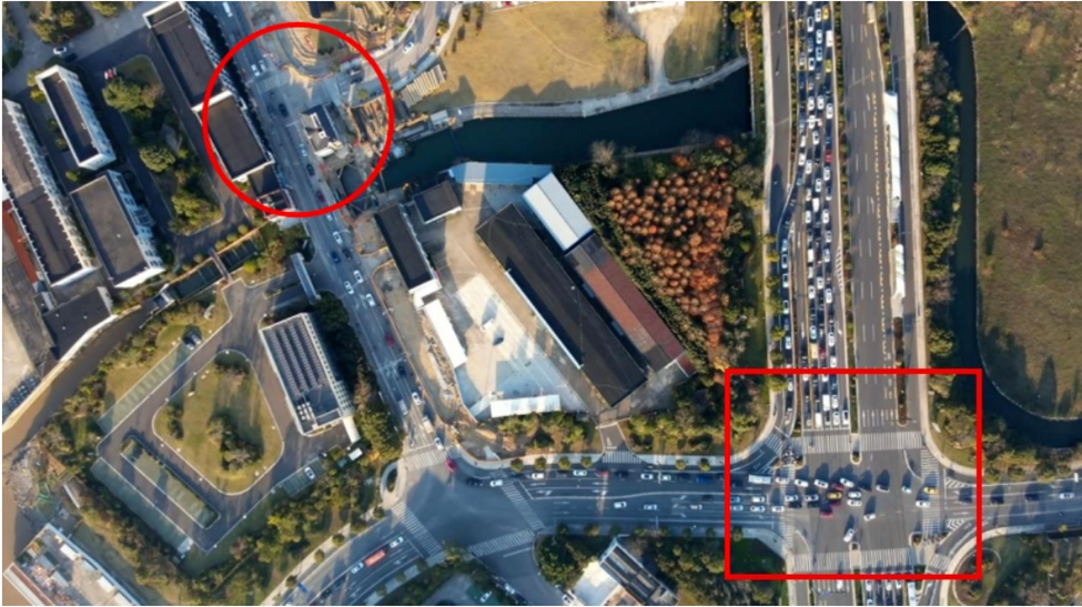
1. Rapidly pinpointing congestion sources across intersections.
During peak congestion on Hai Tian Avenue and Zhe Da Road in our city (as indicated by the red square in the diagram), we used drones to identify the congestion source, which was found to be a small T-shaped intersection one intersection away (as indicated by the red circle in the diagram). Subsequently, we re-marked the lines at that T-shaped intersection, effectively resolving the congestion issue, as shown in the following two images.
Before treatment of Hai Tian Avenue and Zhe Da Road.
.png)
After treatment of Hai Tian Avenue and Zhe Da Road.
2. Real-time comprehensive display of signal linkage control effects.
During peak hours, intersections with short distances between them require coordinated signal control. At this time, the aerial perspective provided by drones can visually demonstrate the mutual influence of traffic flow throughout the road network. Traffic control personnel can quickly determine coordination plans and make adjustments on the fly, thereby shortening the rectification cycle, as shown in the following two images.
.png)
Before signal linkage control.
.png)
After signal linkage control.
3. Achieving remote consultations through high-precision modeling.
In Zhoushan, the treatment of challenging intersections typically involves consultations among key stakeholders. Before 2023, bringing these stakeholders together required coordinating their work schedules, resulting in significant time costs. However, by utilizing the Skysense 2 platform, we can first use drones to create high-precision models, making remote preliminary consultations among key stakeholders a reality and accelerating work efficiency.
4. Thermal imaging for fog penetration observation.
The Airport drone equipped with the T30 thermal imaging camera. Through our testing, in scenarios where traditional cameras fail due to rain and fog, the thermal imaging capability of drones enables continued monitoring of traffic flow on roads.
After activating thermal imaging.
Challenges
1. Endurance
A critical issue faced in drone applications is endurance, particularly with regards to the mileage requirements posed by the strip-like characteristics of highways. Currently, most drone applications still rely on manual piloting, necessitating constant relocation by the pilot, which poses significant challenges in achieving full coverage of entire road segments.
Simultaneously, the Ministry of Public Security has explicitly stated a requirement of one hour of endurance for drones. However, the endurance capabilities of existing drones on the market generally fall short of this requirement. This often results in the need for customizations or battery modifications to existing drones by law enforcement agencies.
Given these challenges, there is a pressing need to further optimize the endurance of drones. Overall, actual endurance times for drones are lower than the advertised figures due to factors such as environmental differences. For example, DJI's Mavic 3 drone, launched in 2023, claims an endurance exceeding 40 minutes, but in practice, it often lasts only around 30 minutes, with actual monitoring times typically around 20 minutes.
While drones have demonstrated practical significance in traffic management, there are still significant shortcomings. Feedback from traffic police indicates that drones, particularly during peak daytime hours, are severely limited by their short endurance, especially in real-time signal linkage and control. Extending endurance would significantly enhance the effectiveness of drones in data collection and linkage applications.
Some have proposed deploying multiple airports in the same location to achieve seamless rotation of drones. However, this solution faces challenges related to high costs and spatial limitations. Each airport requires a backup landing point, and the required space exceeds 5 square meters. The limited rooftop space in urban areas makes deploying multiple airports difficult.
.png)
Drone airport and emergency landing site.
2. Positioning
Although the current drone flight control systems are relatively stable, in remote areas, weak satellite signals can lead to inaccurate positioning, resulting in situations such as drone loss of control.
Considering safety concerns, current regulations stipulate that drones can only fly alongside highways, significantly limiting their application range. Therefore, industry professionals suggest that drones used alongside highways could benefit from dual navigation systems, namely GPS and BeiDou systems. The industry is also exploring and looking forward to better solutions.
3. Data and Network Security
Compared to other types of big data, the data collected during the application of drones is characterized by deeper industry verticality and a stronger capacity for collecting personal information and other data. Therefore, ensuring that the systems and entities involved in drones, including drone manufacturers and users, comply with regulations in handling data and strictly adhere to requirements for network security and data security compliance is a crucial issue that drone manufacturers and users must prioritize.
Market Participants
According to 7ITS, in the field of transportation, DJI drones dominate the market absolutely. In addition to DJI, there are also companies like Hikvision, Dahua, Hubsan, and Yuneec.
Specifically, within the DJI ecosystem, the M300, known for its long endurance, is commonly used for road patrols but requires a professional pilot due to its large takeoff weight. The M3T, portable, practical, and cost-effective, is the most favored single-operator drone. The Airport series can autonomously cruise, with the full set of Airport 1 costing about 200,000 RMB and Airport 2 about 100,000 RMB, making them more economical compared to other products in the market.
Hikvision's main products include quadcopter and hexacopter drones, as well as automatic flight inspection systems and anti-drone defense systems. These products, combined with traditional security and visual advantages, are widely used in law enforcement and traffic aviation sectors.
Additionally, there are other drone manufacturers whose products can be used in the transportation sector. For example, Yuneec Typhoon H520 drone is suitable for scenarios such as road surveying and traffic flow monitoring in transportation planning.
Apart from these drone manufacturers, there are also companies offering solutions for drone industry applications. For example, Forray Intelligence relies on hardware platforms such as battery-swapping stations, charging stations, and flight control systems, as well as cloud platforms for perception recognition algorithms, task control, and automatic flight algorithms. They provide customized solutions for public security patrols and highway patrols to optimize user experience. Similar products include Dayi Hangkong's Kite Line Cloud Management Platform, and so on.
User Requirements
1. Urban Traffic Management
Regarding purchasing intentions, based on user surveys, some users wish to continue procuring drones to supplement deficiencies in surveillance systems, enhancing road condition monitoring and event response efficiency. However, some users currently express no procurement needs unless new applications are developed or real-time capabilities are improved. There is a lack of consensus on this issue.
To address the above issues, key solutions include improving the integration of drone video into private networks, optimizing platforms such as user interfaces and customized data collection functions. Additionally, back-end algorithm optimization and the enhancement of robust data analysis and processing capabilities are essential to achieve linkage between relevant data and platforms. Extending endurance to meet continuous monitoring needs is also a crucial consideration.
2. Highway Applications
According to user surveys, most users have a strong demand for drone applications mainly because drones can effectively replace manpower, reduce workloads, and improve efficiency.
In highway applications, safety, performance, and endurance are the core considerations for drones. Among them, safety is the most critical factor. From a modern social media perspective, any flight accident could significantly impact the further application of drones and public trust levels. Performance determines the drone's task execution capability, while endurance is related to its usage duration. Although these factors can be addressed by purchasing more drones, the associated increase in cost and complexity may affect further drone applications on highways.
Closing Thoughts
Drones have brought a "leap in dimension" to traditional traffic management. With their unique perspective, automated operation, efficient data collection, and adaptable capabilities, drones have injected new vitality into traditional traffic management.
However, the rise of emerging technologies often faces multiple challenges, and drone technology is no exception. Constraints on endurance, considerations of cost, concerns about the security, accuracy, and speed of control and data transmission, as well as potential issues, all urgently require exploration and resolution.
It is through addressing these challenges that we can harness the full potential of drone technology and continue to revolutionize the field of traffic management for the better.
Reference:
Flying Over Traffic: The Innovative Journey of Drones in Urban Roads and Highway Management (Zhao Guanhua)
A Brief Discussion on the Application of Drones in Traffic Management (Wang Bin)